Right now
Right now as of Oct 28, 2026
- Status Na Ala Hele lists the Mānana Trail as open (read Oct 28, 2026).
Status note (Oct 28, 2026): Na Ala Hele lists the Mānana Trail as open (read Oct 28, 2026). Its trail page describes a signed right fork down to waterfalls and pools in Waimano Valley. The falls spur is not a managed trail, so no agency posts a status for it. We found no closure notice. What the status labels mean
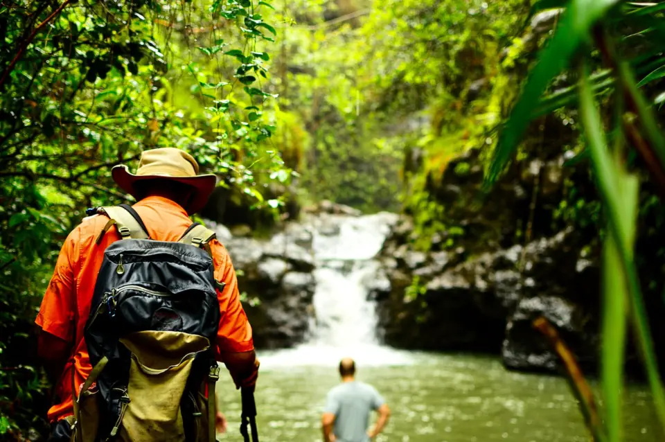
Waimano Falls is a rain-fed waterfall and pool area near Pearl City on Oahu. A 2016 Honolulu Magazine article put the hike at about 3 miles round trip from the end of Komo Mai Drive in Pacific Palisades. Na Ala Hele lists the Mānana Trail as open and describes the fork to the falls, but the spur itself is not a managed trail.
About Waimano Falls
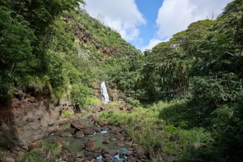
Waimano Falls, sometimes called Waimano Falls and Pools, is near Pearl City on Oahu. Honolulu Magazine wrote in 2016 that the falls run only after recent rain. On that writer's visit, the pool was dry.
We found no official height. The map pin is the approximate end of the Waimano Falls Trail in OpenStreetMap, not a mapped waterfall point. For driving, head to the end of Komo Mai Drive.
The access route is the Mānana Trail, a state trail in the Ewa Forest Reserve (Waimano section). Na Ala Hele's route description notes a signed junction where the right fork leads down a side ridge to several waterfalls and pools in Waimano Valley.
Na Ala Hele also warns that trails branching off its named routes may be on private property and are not managed for public recreational use. That is why no agency posts a status for the falls spur.
Don't confuse this hike with Na Ala Hele's official Waimano Trail, which starts on Waimano Home Road. It is also not Waimea Falls on the North Shore.
Getting there and parking
Park on the street at the end of Komo Mai Drive in Pacific Palisades and walk through the pedestrian passage beside the locked gate.
Komo Mai Drive and parking
Na Ala Hele's directions: take the Pearl City/Waimalu exit off H-1, then Moanalua Road, Waimano Home Road and Komo Mai Drive to its end in Pacific Palisades.
A locked gate at the end of Komo Mai Drive stops vehicles. Na Ala Hele and DLNR's Forestry and Wildlife listing both say to park there and walk through the pedestrian passage beside the gate.
Parking is on the street and limited, and Honolulu Magazine advised arriving early, especially on weekends. Na Ala Hele asks hikers to respect the trailhead community by keeping noise down, not littering and parking responsibly.
Register at the hunter and hiker check-in mailbox on the right at the start, Na Ala Hele says. The magazine reported no fee, and we found no permit requirement for the Mānana Trail.
Map and nearby falls
Map loads as you scroll. Open in OpenStreetMap
OpenPartly open / seasonalUnconfirmedClosedLarger map
The Waimano Falls trail
The hike to Waimano Falls follows the Mānana Trail, then a steep, unmanaged spur down to the falls. Honolulu Magazine (2016) put it at about 3 miles round trip.
Mānana Trail section
Follow the Mānana Trail up the ridge. Na Ala Hele lists the full trail at 6 miles to the Koʻolau summit, with 1,700 feet of elevation. Its listed hazards include dangerous cliffs, a narrow trail, uneven surfaces, sun exposure and a hunting area.
At a signed junction, the main trail keeps left around a hump on the ridge. The right fork leads down a side ridge to the waterfalls and pools, according to Na Ala Hele.
According to Na Ala Hele, Charles Nakamura and friends from the Hawaiian Trail and Mountain Club began clearing the Mānana Trail in 1965. They reached the summit in 1969.
The steep spur to the falls
Honolulu Magazine put the whole hike at about 3 miles round trip and rated it moderate, with steep, root-covered sections including a stretch nicknamed 'Cardiac Hill'.
Hiking Project rates the falls spur harder. It calls the 0.6-mile spur Difficult, with steep, tricky terrain, a descent of about 497 feet and a maximum grade of 34%.
Hike time
The magazine said the hike usually takes more than an hour. Its writer reached the falls in under an hour and walked back in about 45 minutes. Allow more time when the ground is muddy.
It is also a hunting trail, so you may meet hunting dogs and pigs. Keep children close and give animals plenty of room. There are no restrooms on the trail, so bring enough water for the full round trip.
When to visit
Go after rain if you want to see water. Honolulu Magazine said the falls flow only after recent rain, and the pool can be dry in dry weather.
Rain brings its own risk, though. DLNR's Na Ala Hele hiking-safety guidance warns that rain on the ridges can raise streams suddenly, and all forest reserves close during tropical storm and hurricane warnings.
The magazine said the hike isn't crowded like Makapuʻu Point Lighthouse, but street parking is very limited on weekends.
We found no closure notice for the Mānana Trail or the falls (checked Oct 28, 2026). For a falls hike on a managed trail, see Mānoa Falls in Honolulu.
| Trail | About 3 mi round trip from the Mānana Trail at the end of Komo Mai Drive (Honolulu Magazine, 2016) |
|---|---|
| Difficulty | Moderate to difficult: Honolulu Magazine says moderate; Hiking Project rates the 0.6 mi falls spur Difficult |
| Time needed | The 2016 writer took under an hour out and about 45 minutes back (Honolulu Magazine) |
| Entry fee | No fee reported (Honolulu Magazine, 2016) |
| Parking | Limited street parking on Komo Mai Drive |
| Dogs | Leashed dogs allowed on the Mānana Trail, and remove dog waste (Na Ala Hele); hunting dogs may be off-leash during a hunt. No rule found for the falls spur |
| Swimming | No official swimming area; Hawaii DOH advises against freshwater swimming (leptospirosis) |
| Wheelchair / stroller | No |
| Restrooms | None on the trail (Honolulu Magazine, 2016) |
| Crowds | Not crowded compared with hikes like Makapuʻu Point Lighthouse, but street parking is very limited on weekends (Honolulu Magazine, 2016) |
| Managed by | Hawaii DLNR Division of Forestry and Wildlife (Mānana access trail, Ewa Forest Reserve; no agency manages the falls spur) |
Safety and swimming
On March 26, 2026, HFD airlifted a hiker in her 20s with a lower-leg injury from the Waimano Falls Trail in Pearl City, the department reported. Watch your footing on roots and steep ground, and wear shoes with good grip.
There's no official swimming area. The Hawaii Department of Health advises against swimming or wading in any freshwater stream or pond in Hawaii because of leptospirosis. Honolulu Magazine also warned about leptospirosis in its 2016 article.
The Department of Health says not to drink stream water unless it has been boiled or treated.
Where to stay near Waimano Falls
Compare hotels, cabins and rentals close to the falls around Pearl City (Pacific Palisades).
See places to stay nearbyAffiliate link: we may earn a commission at no cost to you. Partners do not see or change our waterfall facts. Disclosure.
Waimano Falls FAQ
Is the Waimano Falls trail open?
The access trail is. Na Ala Hele lists the Mānana Trail as open (read Oct 28, 2026) and describes the fork to the falls. The falls spur is not a managed trail, so no agency posts a status for it. We found no closure notice.
How long is the Waimano Falls hike?
About 3 miles round trip from the end of Komo Mai Drive in Pacific Palisades, according to Honolulu Magazine (2016). It rated the hike moderate, with steep, root-covered sections. Hiking Project rates the 0.6-mile falls spur Difficult.
How long does it take to hike Waimano Falls?
There's no official time. Honolulu Magazine said it usually takes more than an hour; its writer reached the falls in under an hour and returned in about 45 minutes. Allow longer when it's muddy.
How do you get to Waimano Falls?
Drive to the end of Komo Mai Drive in Pacific Palisades and walk through the pedestrian passage beside the locked gate. Sign in at the hunter and hiker mailbox, then follow the Mānana Trail to a signed junction, where the right fork leads down to the falls. That fork isn't a managed trail, and Na Ala Hele says branch trails may cross private land.
Where do you park for Waimano Falls?
On the street at the end of Komo Mai Drive in Pacific Palisades. Honolulu Magazine said spaces are limited, so arrive early on weekends. Na Ala Hele asks hikers to park responsibly and keep noise down.
Is Waimano Falls flowing right now?
Only after recent rain, per Honolulu Magazine (2016). The pool was dry on its writer's visit.
Can you swim at Waimano Falls?
There's no official swimming area, and the Hawaii Department of Health advises against swimming in freshwater because of leptospirosis.
Is Waimano Falls the same as the Waimano Trail?
No. Na Ala Hele's official Waimano Trail starts on Waimano Home Road. The falls hike starts from the Mānana Trail at the end of Komo Mai Drive.
Nearby waterfalls
Sources
- Na Ala Hele: Waimano Trail Access, OA 09 021 (trail record)
- Honolulu Magazine: Waimano Falls and Pools (Apr 28, 2016)
- HFD: Injured hiker rescued on Waimano Falls Trail (3/26/26)
- Na Ala Hele: Mānana Trail, OA 09 008 (trail record, read Oct 28, 2026)
- DLNR DOFAW camping and permits: Manana Trail (Ewa Forest Reserve, Waimano section)
- Hiking Project: Waimano Falls Spur
- Hawaii DOH: Leptospirosis
- DLNR Na Ala Hele: Hiking safety
- OpenStreetMap: Waimano Falls Trail (way 450182872; map pin is the trail end, approximate)
Last verified Oct 28, 2026 by The Waterfall Guide editorial team. Conditions change: confirm with Hawaii DLNR Division of Forestry and Wildlife (Mānana access trail, Ewa Forest Reserve; no agency manages the falls spur) before you go. Spotted something out of date? Report a correction.