Right now
Right now as of Oct 29, 2026
- Status Seasonal road access.
- Permit No permit needed. Fee: no fee found (unconfirmed).
Status note (Oct 29, 2026): Seasonal road access. In 2026 the Hyalite Canyon Road closed to vehicles April 1 to May 15. In winter the trailhead road closes and you walk about 2 miles (Visit Bozeman). On October 29, 2026, the Custer Gallatin alerts page listed no closure for Palisade Falls or the Hyalite Canyon Road. What the status labels mean
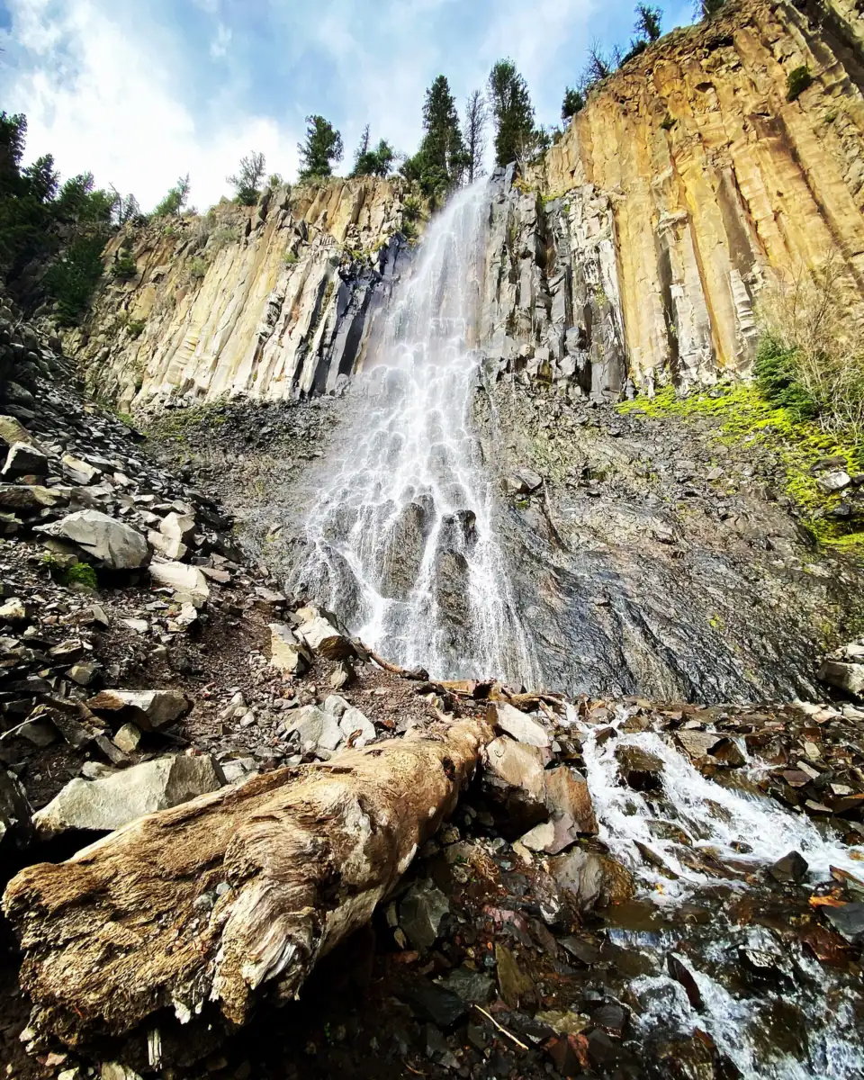
Palisade Falls drops more than 80 feet off a vertical rock wall in Hyalite Canyon near Bozeman, Montana, per Visit Montana. The Forest Service trailhead page describes a half-mile nature trail, fully accessible and paved, in the Custer Gallatin National Forest. In winter, Visit Bozeman says, the trailhead road closes and you walk about 2 miles from the gate. As of October 29, 2026, we found no closure beyond the spring 2026 road closure, April 1 to May 15.
About Palisade Falls
Visit Montana says Palisade Falls drops more than 80 feet off a vertical rock wall at the southern base of Palisade Mountain. Visit Bozeman calls it an 80-foot drop. We found no Forest Service or USGS height.
The water comes from a tributary of the East Fork of Hyalite Creek, according to Visit Montana. The trail follows that stream to a bridge facing the falls.
The falls are in the Custer Gallatin National Forest, managed by the Bozeman Ranger District. The Forest Service trailhead page lists a picnic area at the site. The trail was designated a National Recreation Trail on November 30, 1977, though that database warns its record may be out of date.
Visit Bozeman calls Palisade Falls a local favorite for families. In winter, it says, the frozen falls are popular with ice climbers.
Getting there and parking
Drive Hyalite Canyon Road (FS 62) past Hyalite Reservoir. Then turn left onto the East Fork Hyalite road and follow it about a mile to the Palisade Falls Trailhead.
Arrive early in summer. Visit Bozeman says Hyalite day-use lots fill quickly on summer weekends. It also says the East Fork road may open later than the main road in early summer and sometimes closes for paving.
The Forest Service trailhead page lists an accessible vault toilet at the trailhead but no drinking water. Bring your own water.
We found no day-use fee in Forest Service excerpts or in Visit Bozeman's Hyalite guide, updated July 8, 2026. The falls are on national forest land, so no park entrance fee applies. We could not confirm with the agency that parking is free.
For road or trail questions, the Bozeman Ranger District number is 406-522-2520.
Planning more of the state? Our guide to waterfalls in Montana compares this falls with Kootenai Falls near Libby and St. Mary Falls in Glacier National Park.
Map and nearby falls
Map loads as you scroll. Open in OpenStreetMap
OpenPartly open / seasonalUnconfirmedClosedLarger map
The hike
The Palisade Falls trail is about 1 mile round trip, per the Forest Service trailhead page, which describes a half-mile nature trail. The 1977 National Recreation Trail record lists 0.6 mile, and trail guides such as Hiking Project list 1.2 miles round trip.
Visit Montana calls it an easy summer hike that ends at a bridge facing the falls. We found no official elevation gain or walking time.
Accessibility is where the sources differ most. The Forest Service trailhead page, updated February 19, 2025, calls it a 'Popular 1/2 mile nature trail, fully accessible and paved'. The 1977 trail record agrees. Visit Bozeman describes a mostly paved trail with a few somewhat steep sections. Visit Montana also calls the trail wheelchair- and stroller-accessible and mostly paved.
Trail guides such as Hiking Project add that the pavement ends before the final pitch to the base of the falls. If you use a wheelchair, ask the ranger district about current conditions before you go.
When to visit
Road dates decide when you can drive to Palisade Falls. For 2026, the Forest Service closed the whole Hyalite Canyon Recreation Corridor to motor vehicles from April 1 through May 15. The gate shut at 6 p.m. on March 31, and the road reopened May 16.
The closure protects the road during the spring thaw, and walking, running and biking stayed allowed. Forest Service recreation program manager Kat Barker said, 'The six-week period of no traffic in the canyon offers a unique, non-motorized recreational experience.'
Winter access takes more effort. Visit Bozeman says the road to the Palisade Falls Trailhead is closed in winter. You park at the gate past Hyalite Reservoir and walk about 2 miles, and it recommends snowshoes.
Gallatin County plows Hyalite Canyon Road, with costs shared by Friends of Hyalite and the Forest Service. Plowing comes after higher-priority county roads, and Recreation.gov warns that visitors 'should NOT assume that the road will get plowed immediately after every storm.'
Recreation.gov recommends four-wheel drive, high clearance, and snow tires or chains. It warns that winter conditions may stop vehicles at the lower gate, about 2 miles south of the Hyalite Canyon Road and South 19th Avenue junction.
As of October 29, 2026, we found no 2026 closure notice for the trail or the East Fork road other than the spring closure. That day the Forest Service trailhead page and the forest's alerts page showed no closure. We could not confirm the winter 2026-27 gate date or the best month for flow.
| Height | 80 ftNote: more than 80 ft off a vertical rock wall, per Visit Montana; Visit Bozeman says 80 ft, and we found no Forest Service figure |
|---|---|
| Trail | Half-mile nature trail, 'fully accessible and paved', per the Forest Service trailhead page; about 1 mi round trip. The 1977 National Recreation Trail record lists 0.6 mi; trail guides such as Hiking Project list 1.2 mi round trip |
| Difficulty | Easy (Visit Montana), with a few somewhat steep sections (Visit Bozeman) |
| Entry fee | We found no fee in Forest Service excerpts or in Visit Bozeman's Hyalite guide (updated July 8, 2026). We could not confirm with the agency that the trailhead is free. No national park entrance fee applies on national forest land. |
| Permit / reservation | No permit found; the Hyalite Canyon Road closes to vehicles each spring and the trailhead road closes in winter |
| Parking | Trailhead on East Fork road |
| Dogs | We found no agency dog rule for Palisade Falls |
| Swimming | We found no agency swimming rule for Palisade Falls |
| Wheelchair / stroller | Yes, per the Forest Service trailhead page, which calls the trail 'fully accessible and paved'. Visit Bozeman notes a few somewhat steep sections, and trail guides such as Hiking Project say the pavement ends before the final pitch to the base |
| Walk behind the falls | No |
| Restrooms | Accessible vault toilet at the trailhead; no drinking water (Forest Service trailhead page) |
| Crowds | Visit Bozeman says Hyalite day-use lots fill quickly on summer weekends and calls the falls a local favorite for families |
| Managed by | USDA Forest Service, Custer Gallatin National Forest (Bozeman Ranger District) |
Safety and swimming
We found no agency swimming or dog rule for Palisade Falls. Stay on the trail and the bridge, and keep off the wet rock at the base.
This is bear country. A Forest Service food storage order covers the Bozeman Ranger District through December 1, 2026, according to a release we saw only as a search excerpt. Store food in a hard-sided vehicle or enclosed trailer, or in an approved bear-resistant container.
Where neither is possible, the order allows hanging food at least 10 feet above the ground and 4 feet from trees or poles. Montana Fish, Wildlife and Parks advises carrying bear spray where you can reach it and knowing how to use it, NBC Montana reported.
Winter adds its own hazards. The walk in from the gate is about 2 miles, and the frozen falls draw ice climbers. Do not stand below climbers or hanging ice.
Recreation.gov says not to assume Hyalite Canyon Road will be plowed right after every storm, so check conditions and carry winter gear in the car. Our waterfall safety guide covers ice and slick rock near falls.
Where to stay near Palisade Falls
Compare hotels, cabins and rentals close to the falls around Bozeman.
See places to stay nearbyAffiliate link: we may earn a commission at no cost to you. Partners do not see or change our waterfall facts. Disclosure.
Palisade Falls FAQ
How long is the Palisade Falls hike?
About 1 mile round trip. The Forest Service trailhead page describes a half-mile paved nature trail. Trail guides such as Hiking Project list 1.2 miles round trip, and the 1977 National Recreation Trail record lists 0.6 mile.
Is Palisade Falls wheelchair accessible?
Yes, per the Forest Service trailhead page, which calls the trail 'fully accessible and paved'. Visit Bozeman mentions a few somewhat steep sections. Trail guides such as Hiking Project say the pavement stops before the last pitch to the base.
Is Hyalite Canyon closed?
Not as of October 29, 2026, as far as we found. That day the Forest Service trailhead page and the forest's alerts page showed no closure. The canyon road closes to vehicles each spring; in 2026 that ran April 1 through May 15.
Can you visit Palisade Falls in winter?
Yes, on foot. Visit Bozeman says the trailhead road is closed in winter, so you park at the gate past Hyalite Reservoir and walk about 2 miles. Snowshoes help, and Recreation.gov warns the main road may not be plowed right after every storm.
How tall is Palisade Falls?
More than 80 feet, according to Visit Montana, which says it pours off a vertical rock wall at the base of Palisade Mountain. We found no Forest Service height.
What town is near Palisade Falls?
Bozeman. The falls are up Hyalite Canyon in the Custer Gallatin National Forest, and the Bozeman Ranger District manages the trailhead.
Does the Palisade Falls picnic area have restrooms?
Yes. The Forest Service trailhead page lists an accessible vault toilet and a picnic area at the trailhead, but no drinking water.
Nearby waterfalls
 Tower Fall48 mi straight-lineSeasonal132FT
 Gibbon Falls57 mi straight-lineSeasonal84FT
 Fairy Falls66 mi straight-lineSeasonal200FT
On these lists: Easy waterfall hikes
Sources
We read the Forest Service's Palisade Falls Trailhead page on October 29, 2026. Its Hyalite Canyon and food storage pages, and the NBC Montana bear-safety article, blocked our checks. Facts credited to them come from search-result excerpts. Confirm fees and rules on the official site.
- USFS Custer Gallatin: Palisade Falls Trailhead (updated Feb 19, 2025; read Oct 29, 2026)
- USFS destinations listing incl. Palisade Falls Trailhead (via search excerpt)
- USFS release: Hyalite Canyon to temporarily close for spring road preservation (Mar 25, 2026; via search excerpt)
- USFS release: Requirements for food storage reinstated March 1 (Feb 27, 2026; via search excerpt)
- Explore Big Sky: Hyalite Canyon Road to close for seasonal non-motorized recreational access (Mar 30, 2026)
- Recreation.gov: Window Rock Cabin (Hyalite winter plowing and gate info)
- Visit Montana: Palisade Falls Trail
- Visit Bozeman: 3 Winter Waterfall Hikes Near Bozeman (updated Dec 22, 2022)
- Visit Bozeman: ADA Accessible Trails Near Bozeman (updated May 30, 2023)
- Visit Bozeman: Hyalite Canyon guide (updated Jul 8, 2026)
- National Recreation Trails database: Palisade Falls
- NBC Montana: Montana FWP shares tips for recreating in bear country (Sept 2026; via search excerpt)
- Wikipedia: Hyalite Reservoir (county)
- USDA Forest Service: Custer Gallatin National Forest alerts (read Oct 29, 2026)
Last verified Oct 29, 2026 by The Waterfall Guide editorial team. Conditions change: confirm with USDA Forest Service, Custer Gallatin National Forest (Bozeman Ranger District) before you go. Spotted something out of date? Report a correction.