Planning guide
Tallest waterfalls in the US
The tallest waterfall in the US is Haloku Falls (2,910 ft), per the World Waterfall Database's 2026 lidar update. Yosemite Falls (2,425 ft) has NPS trails.
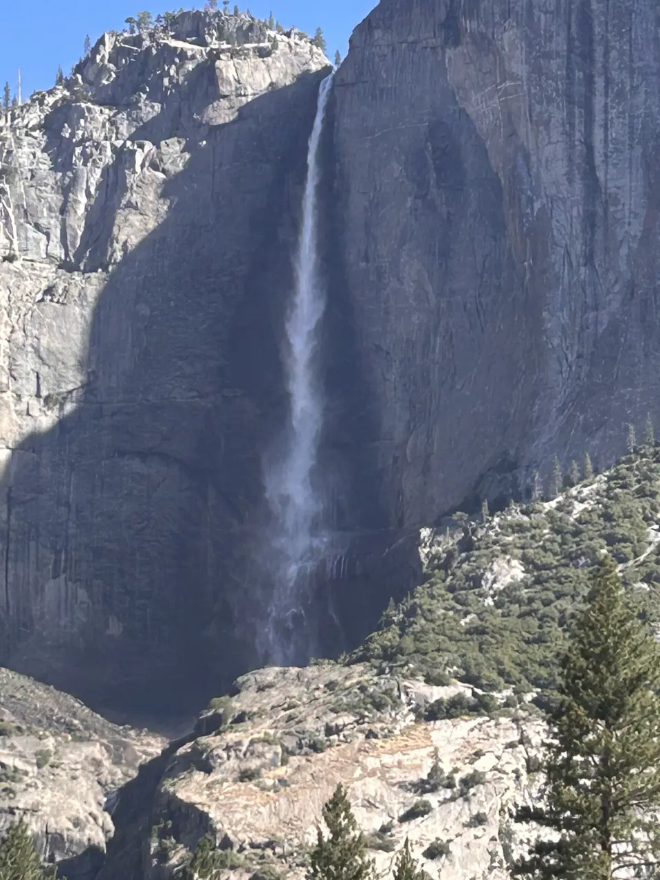
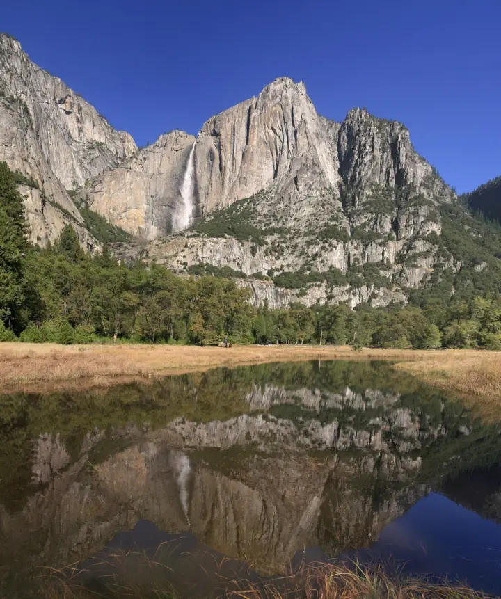
The tallest waterfall in the US is now Haloku Falls on Molokai, Hawaii, at 2,910 ft. That ranking comes from the World Waterfall Database (WWD), which revised its Molokai entries with lidar data on October 17, 2026. Many lists still name Oloʻupena Falls at 2,953 ft. WWD now gives Oloʻupena 2,880 ft. For a giant with an official trail, Yosemite Falls in California is 2,425 ft, according to the National Park Service (NPS).
Even the highest waterfall in the US has only an estimated height, so treat every figure on this page as an estimate. There is no standard way to measure a waterfall, and the sources use different methods. So we show each figure with its source and, where known, how it was measured. For more falls by region, see our state-by-state waterfall pages.
What is the tallest waterfall in the United States?
By the World Waterfall Database's current figures, it's Haloku Falls on Molokai at 2,910 ft. WWD says "Lidar data indicates the falls to have a cumulative drop of just over 2,900 feet in about eleven distinct tiers". Its tallest single drop is 1,440 ft.
Before October 2026, most lists put Oloʻupena Falls first at 2,953 ft. Wikipedia's Oloʻupena article still uses that figure and cites WWD for it. WWD has since revised it: "We had previously estimated Olo'upena Falls to drop roughly 2,950 feet … lidar data indicates the actual height to be slightly shorter". The new figure is 2,880 ft over about 17 tiers.
All three Molokai falls carry WWD's "Unconfirmed" status. WWD defines that as "Statistical information may be estimated and may be inaccurate". In plain terms, the lidar figures are the best current estimate, not a surveyed measurement. They could change again.
The 10 tallest waterfalls in the US
This table follows WWD's US tallest list as we read it on October 24, 2026. We kept its two unnamed Hawaii entries so the ranking stays honest. Yosemite Falls sits just below the top 10, so we added it as row 11.
| Rank | Waterfall | State | Total height | Drops or tiers | How measured / WWD status | Can you see it? |
|---|---|---|---|---|---|---|
| 1 | Haloku Falls | HI (Molokai) | 2,910 ft | 11 tiers | Lidar, Oct 2026 / Unconfirmed | By boat or air only |
| 2 | Oloʻupena Falls | HI (Molokai) | 2,880 ft | 17 tiers | Lidar, Oct 2026 / Unconfirmed | By boat or air only |
| 3 | Puʻukaʻoku Falls | HI (Molokai) | 2,665 ft | 8 tiers | Lidar, Oct 2026 / Unconfirmed | By boat or air only |
| 4 | Waihilau Falls | HI (Hawaii Island) | 2,600 ft | 1 drop | USGS topo maps / Confirmed | Waimanu Valley access is restricted (see Safety) |
| 5 | Colonial Creek Falls | WA | 2,568 ft | 13 drops | Triangulation survey / Cataloged | Glimpsed from the Diablo Lake Thunder Arm area |
| 6 | Isella Falls | WA | 2,500 ft | Not listed | Not listed | From the Railroad Creek Trail |
| 7 | Unnamed (Hawaii) | HI | 2,480 ft | Not listed | Not listed | We could not confirm |
| 8 | Johannesburg Falls | WA | 2,465 ft | 5 drops | USGS topo maps / Cataloged | From Cascade River Road |
| 9 | Unnamed (Hawaii) | HI | 2,435 ft | Not listed | Not listed | We could not confirm |
| 10 | Wailele Falls | HI | 2,430 ft | Not listed | Not listed | We could not confirm |
| 11 | Yosemite Falls | CA | 2,425 ft | 3 parts | NPS figure | Yes, by trail |
Heights are WWD's, except Yosemite Falls, which uses the NPS figure (WWD lists the same 2,425 ft). "Not listed" means our research didn't capture that detail from WWD.
Further down WWD's list are more Washington and Hawaii falls and Montana's Boulder Glacier Falls (2,385 ft). Sentinel Fall in Yosemite (2,070 ft) and Thunder Falls in Alaska (2,000 ft) follow. WWD says Thunder Falls can be seen from boats touring LeConte Bay, east of Petersburg.
Why lists disagree
Lists disagree because there is no shared rule for measuring a waterfall. Wikipedia's "List of waterfalls by height" says it directly: "There is no standard way to measure the height of a waterfall". It adds that heights "are merely estimates and measures may be imprecise."
Total height vs tallest drop
WWD uses two different numbers. Total height is the figure that, in WWD's words, "represents the difference in elevation from the top of the uppermost drop, to the bottom of the lowermost drop", counting every tier. Tallest drop is the figure that "represents the height of the largest single drop within a multi-stepped waterfall". A list that mixes the two will rank falls differently.
Measurement methods and status labels
The figures we could trace come from three methods:
- USGS topographic maps: Waihilau and Johannesburg, plus Thunder Falls further down the list. WWD says of Thunder Falls that "no official measurement has been known to have been taken".
- Triangulation survey: Colonial Creek, surveyed in August 2011 and again in March 2017.
- Lidar: the three Molokai falls, in October 2026.
Our research didn't capture the method for Isella, Wailele or the two unnamed Hawaii falls.
WWD also labels how much to trust each entry. "Cataloged" means "visited and surveyed in person". "Confirmed" means "statistical information available will often be dependable". "Unconfirmed" means the figures "may be estimated and may be inaccurate".
Seasonal streams
Some of the tallest falls only run in wet weather. WWD and Wikipedia describe the Molokai sea-cliff falls as wet-weather, seasonal streams. Geology.com says their streams are intermittent and that it could not find who determined the heights of Oloʻupena and Puʻukaʻoku.
Even the federal data has gaps. The USGS Waterfalls and Rapids dataset covers 10,780 waterfalls in the lower 48 states, but it includes height only "when available".
How much the numbers move
| Waterfall | One figure | Another figure | Gap |
|---|---|---|---|
| Oloʻupena Falls | 2,953 ft (older lists, Wikipedia) | 2,880 ft (WWD lidar, 2026) | 73 ft |
| Puʻukaʻoku Falls | 2,756 ft (older lists, Wikipedia and geology.com) | 2,665 ft (WWD lidar, 2026) | 91 ft |
| Colonial Creek Falls | 2,584 ft (WWD's first topo estimate) | 2,568 ft (WWD survey) | 16 ft |
| Colonial Creek Falls | 2,585 ft (Wikipedia height list) | 2,568 ft (WWD survey) | 17 ft |
| Waihilau Falls | 2,598 ft (Wikipedia) | 2,600 ft (WWD) | 2 ft |
| Multnomah Falls | 620 ft (NPS) | 632 ft (WWD) | 12 ft |
Our read: most gaps are small next to the heights themselves. The biggest swings come when a source changes method, as with the move from earlier estimates to lidar on Molokai. Oloʻupena's 73 ft cut, together with Haloku's new 2,910 ft figure, moved it to second place.
Tallest waterfall in the lower 48
The tallest waterfall in the lower 48 states is Colonial Creek Falls in Washington's North Cascades National Park, at 2,568 ft by WWD's survey. Wikipedia calls it the "tallest waterfall in the continental United States". WWD lists it with 13 drops and the status Cataloged.
WWD's first estimate of 2,584 ft "was derived entirely from topographic data". A triangulation survey in August 2011 replaced it, and WWD says the result is "not likely to be off by more than 50 feet". The falls are glacier-fed and flow all year, at about 40 to 100 cubic feet per second.
You can glimpse Colonial Creek Falls from parts of the Diablo Lake Thunder Arm valley. WWD warns that getting close takes "an immense effort". We could not find an NPS viewpoint page for it.
Two easier Washington views
Isella Falls (2,500 ft, WWD) runs off the Isella Glacier in Chelan County. WWD says you can see it from the Railroad Creek Trail. We could not confirm which agency manages the area.
Johannesburg Falls (2,465 ft, WWD) is in the Skagit County part of North Cascades National Park. WWD says you can see it from Cascade River Road for about ¾ mile, starting near mile 21.5 by Boston Creek. The road ends at the Cascade Pass trailhead at mile 23.
Johannesburg's flow can drop to 0 cubic feet per second, and WWD lists June to October as the best months. We could not confirm the current road status, so check with the park before you drive. For more falls in the state, see our Washington waterfalls page.
Yosemite Falls: the tallest with an official trail to it
Yosemite Falls is 2,425 ft tall, according to the NPS. Of the falls we could check, it's the tallest with an official trail to it. Isella and Johannesburg rank higher, but you see them from the Railroad Creek Trail and Cascade River Road. The NPS waterfalls page calls it "one of the world's tallest". The NPS place page calls it "one of the tallest waterfalls in North America". The NPS doesn't claim it's the tallest in North America.
NPS says it's "made up of three separate falls": Upper Yosemite Fall (1,430 ft), the middle cascades (675 ft) and Lower Yosemite Fall (320 ft). It's fed entirely by snowmelt.
When it flows
The falls run "approximately November through July, with peak flow in May", per NPS. Peak runoff is typically in May or June. By August, NPS says, Yosemite Falls is "often only a trickle or completely dry". Plan a spring visit if you want to see it full.
The two trails
- Lower Yosemite Fall loop: 1 mile, about 50 ft of gain, easy, about 30 minutes. NPS says it's open year-round, and the eastern part is wheelchair accessible when it isn't covered in ice or snow.
- Upper Yosemite Fall trail: 2 miles round trip and 1,000 ft of gain to Columbia Rock, about 2 to 3 hours. To the top of the falls it's 7.2 miles round trip, 2,700 ft of gain, strenuous, about 6 to 8 hours.
2026 entry and fees
The NPS said in February 2026 that "Yosemite National Park will not require advance reservations in 2026." The entrance fee is $35 per private vehicle for 7 days. Non-US residents aged 16 and older pay an extra $100 per person, unless they hold an Annual or America the Beautiful pass.
Other tall Yosemite falls
NPS lists Sentinel Falls at "about 2,000 feet", in cascades of 50 to 500 ft. WWD lists it at 2,070 ft. Ribbon Fall is 1,612 ft, and you can see it from the road into Yosemite Valley, just past the Bridalveil Fall turn. Both flow March to June. For a shorter walk, Vernal Fall is 317 ft. Our Yosemite Falls page covers parking and trail details.
Tallest single drop
The answer depends on which WWD page you read. WWD lists Waihilau Falls on Hawaii Island as 1 drop of 2,600 ft. That figure comes from USGS topographic maps: "The wall of the amphitheater is approximately 2600' (792m) tall".
WWD's Ribbon Fall page, updated January 1, 2025, calls Ribbon Fall "the tallest uninterrupted waterfall in the United States", at 1 drop of 1,612 ft. Both claims can't be true. If Waihilau's 2,600 ft is a single drop, it beats Ribbon Fall by almost 1,000 ft. WWD's lidar entry for Puʻukaʻoku Falls also lists a 1,650 ft tallest drop, which would top Ribbon Fall too. That figure is marked Unconfirmed.
Our read: the figures rest on different evidence. Ribbon Fall's 1,612 ft matches the NPS height, though NPS makes no single-drop claim for it. Waihilau's figure is a topo map reading of the amphitheater wall, and Puʻukaʻoku's is an Unconfirmed lidar estimate. Until a survey settles it, treat every "tallest single drop" claim with care. WWD says Ribbon is usually dry by July.
Is there a tallest year-round waterfall?
We couldn't find an authoritative source that answers this. WWD's data points to two candidates that flow all year:
- Waihilau Falls, 2,600 ft: WWD says it flows 12 months, at about 50 cubic feet per second for 11 months and about 1 cubic foot per second for the other month.
- Colonial Creek Falls, 2,568 ft: glacier-fed and flowing all year, per WWD.
Yosemite Falls doesn't qualify, because NPS says it's often dry by August. The Molokai falls are seasonal streams. In Oregon, the Forest Service calls Multnomah Falls "one of the tallest year-round waterfalls in the United States" (page updated April 15, 2026).
Highest waterfall east of the Rockies: competing claims
There is no settled answer. Two agencies name different falls as the highest, a third makes a narrower claim, and a fourth fall is taller in total than any of them.
- Whitewater Falls, North Carolina: a Forest Service Southern Region brochure (slightly revised September 2012) says: "With a 411-foot plunge, Upper Whitewater Falls in North Carolina is the highest waterfall east of the Rockies." Wikipedia, seen only in a search excerpt, calls the claim likely exaggerated and suggests closer to 350 to 400 ft.
- Fall Creek Falls, Tennessee: the Tennessee Division of Natural Areas says "Fall Creek Falls is the highest waterfall east of the Rocky Mountains, plunging 256 feet into a shaded pool" (page modified July 11, 2026).
- Taughannock Falls, New York: NY State Parks says it "plunges 215 feet past rocky cliffs that tower nearly 400 feet". The state Department of Environmental Conservation calls it the "Highest vertical single drop waterfall in NE U.S."
- Amicalola Falls, Georgia: the park's official site calls it "a magnificent 729-foot waterfall that's the third-highest cascading waterfall east of the Mississippi River". Georgia State Parks says the North Georgia Mountains Authority and Coral Hospitality run the park.
Our read: the claims don't measure the same thing. Taughannock's is limited to a single drop in the Northeast. Amicalola's own site ranks it only third among cascading falls east of the Mississippi, yet at 729 ft it's taller in total than Whitewater or Fall Creek. Whitewater's 411 ft figure is itself disputed.
We could not find an official NY State Parks height for Niagara Falls, so we left it out of this comparison.
Tall waterfalls you can visit, by state
These are tall falls from our directory that you can reach on a public trail or viewpoint. Each height matches the figure on its own page. The Source column names the source we cite in this guide.
| Waterfall | State | Height | Source | Access note |
|---|---|---|---|---|
| Yosemite Falls | CA | 2,425 ft | NPS | Lower loop open year-round, per NPS |
| Amicalola Falls | GA | 729 ft | Park's official site | See the falls page |
| Multnomah Falls | OR | 620 ft | NPS | 2026 timed-use permit season (May 22 to Sep 7) has ended |
| ʻAkaka Falls | HI | 442 ft | Hawaii DLNR | Part of the trail closed (notice of 10/19/26) |
| Whitewater Falls | NC | 411 ft (upper falls) | Forest Service brochure (2012) | See the falls page |
| Fall Creek Falls | TN | 256 ft | Tennessee Division of Natural Areas | See the falls page |
| Taughannock Falls | NY | 215 ft | NY State Parks | See the falls page |
Multnomah's height depends on the source. Wikipedia splits it into a 542 ft upper fall, a 69 ft lower fall and a 9 ft gradual drop. It calls Multnomah the "tallest waterfall in the state of Oregon". WWD gives 632 ft and ranks it #2 in Oregon, behind an unnamed 705 ft fall it marks Unconfirmed. Our Multnomah permit guide explains the 2026 timed-use permit.
The Hawaii Department of Land and Natural Resources (DLNR) says ʻAkaka Falls "plunges 442 feet into a stream-eroded gorge". The 0.4-mile loop was partly closed because of fallen trees, per a DLNR notice dated 10/19/26.
Safety and access
Most of the tallest falls have no easy public access. Check the managing agency's alerts before you plan around any of them.
- Molokai sea cliffs: WWD says "No trails exist to the falls, the only access is by watercraft." Wikipedia says they're viewable "only from the ocean or air". We could not confirm who manages the land.
- Waihilau and Waimanu Valley: the DLNR camping page says the Waipiʻo Valley Access Road is "RESTRICTED only to Hawai‘i Island Residents, riding in vehicles". It is also "Closed to all pedestrian use", effective September 19, 2022.
- Waimanu camping: the same page says "CAMPING IS CLOSED" because of "an impassable landslide past Helipad 1". It says "Campsites will reopen November 16, 2026". It calls the 7.6-mile Muliwai Trail "minimally maintained, steep, eroded".
- North Cascades: WWD says reaching Colonial Creek Falls takes "an immense effort". Stay on trails and roads, and view from a distance.
Do not leave the trail near cliff edges, and do not pass barriers. Flow also changes with the season. Several of these falls can shrink to a trickle or stop, so check the season before you travel. Our waterfall safety guide covers slick rock and cliff hazards.
Tallest waterfalls FAQ
Where are the three tallest waterfalls in the US?
All three are on Molokai's north shore sea cliffs in Hawaii. By WWD's October 2026 lidar figures, they are Haloku (2,910 ft), Oloʻupena (2,880 ft) and Puʻukaʻoku (2,665 ft). All are marked Unconfirmed. Older lists give Oloʻupena 2,953 ft, Puʻukaʻoku 2,756 ft and Waihilau about 2,600 ft.
What is the tallest waterfall in the United States?
Haloku Falls on Molokai, at 2,910 ft, according to the World Waterfall Database's October 17, 2026 update. The figure is a lidar estimate that WWD marks Unconfirmed. There is no trail to it.
What is the tallest waterfall in the lower 48 states?
Colonial Creek Falls in Washington's North Cascades National Park, at 2,568 ft by WWD's triangulation survey. Wikipedia calls it the tallest in the continental US. Most visitors only glimpse it from a distance; WWD says getting close takes "an immense effort".
What is the tallest year-round waterfall in the US?
No authoritative source answers this. WWD data suggests Waihilau Falls (2,600 ft) and Colonial Creek Falls (2,568 ft), which both flow all year. Yosemite Falls is often dry by August, per NPS.
What US state has the most waterfalls?
Wikipedia's Washington list says the state has "over 3,000 catalogued waterfalls", more than any other state, citing WWD. WWD's Washington tallest list shows 3,057 results. We could not confirm a state-by-state count on WWD itself.
Is Yosemite Falls the tallest waterfall in North America?
The NPS doesn't say so. It calls it "one of the tallest waterfalls in North America". At 2,425 ft, it's shorter than Colonial Creek, Isella and Johannesburg Falls in Washington on WWD's list.
What is the tallest waterfall in Hawaii?
Haloku Falls on Molokai, at 2,910 ft by WWD's lidar estimate. You can only see it from the sea or air. For a fall with a short trail, ʻAkaka Falls is 442 ft, per DLNR. A DLNR notice of 10/19/26 says part of its 0.4-mile loop is closed by fallen trees, so check before you go. See our Hawaii waterfalls page.
Plan your next step
- Read our Yosemite Falls page for trails, parking and the best months.
- Browse California waterfalls, Hawaii waterfalls and Washington waterfalls.
- Find tall falls near you on the waterfall map.
- Visiting Multnomah Falls in summer? Check the Multnomah Falls permit and parking guide.
Heights last checked October 24, 2026. Conditions change: confirm with the official source before you go.
Sources
- World Waterfall Database: tallest waterfalls in the United States (read Oct 24, 2026): US ranking and heights
- WWD: Haloku Falls (updated Oct 17, 2026): 2,910 ft, 11 tiers, 1,440 ft tallest drop, lidar, Unconfirmed status
- WWD: Oloʻupena Falls (updated Oct 17, 2026): 2,880 ft, 17 tiers, earlier 2,950 ft estimate, watercraft-only access
- WWD: Puʻukaʻoku Falls (updated Oct 17, 2026): 2,665 ft, 8 tiers, lidar
- WWD: Waihilau Falls (updated Mar 19, 2017): 2,600 ft single drop, USGS topo source, year-round flow
- WWD: Colonial Creek Falls (updated Mar 19, 2017): 2,568 ft, 13 drops, triangulation survey, flow, viewing
- WWD: Johannesburg Falls (updated Aug 27, 2017): 2,465 ft, 5 drops, Cascade River Road views, flow
- WWD: Thunder Falls (updated Mar 19, 2017): 2,000 ft topo figure, LeConte Bay boat views
- WWD: Ribbon Fall (updated Jan 1, 2025): "tallest uninterrupted" claim, 1,612 ft single drop
- WWD: tallest waterfalls in Oregon: Multnomah at 632 ft, ranked #2
- WWD: tallest waterfalls in Washington: 3,057 results
- NPS Yosemite: Waterfalls (updated May 12, 2026): Yosemite Falls 2,425 ft and its three parts, flow season, Sentinel and Ribbon heights
- NPS: Yosemite Falls place page (Sep 1, 2025): "one of the tallest waterfalls in North America", snowmelt-fed
- NPS Yosemite: Yosemite Falls Trail (Dec 29, 2024): Columbia Rock and top-of-falls distances, gain and times
- NPS Yosemite: Lower Yosemite Fall Trail (Dec 13, 2024): 1-mile loop, accessibility, year-round access
- NPS release (Feb 18, 2026): no advance reservations at Yosemite in 2026
- NPS Yosemite: Fees (Jan 9, 2026): $35 vehicle fee, $100 non-resident fee
- NPS: Multnomah Falls article (May 19, 2020): 620 ft height
- Hawaii DLNR: ʻAkaka Falls State Park (notice Oct 19, 2026): 442 ft height, 0.4-mile loop, partial trail closure
- Hawaii DLNR: Waimanu camping: Waipiʻo Valley Access Road restrictions, camping closure and reopening date, Muliwai Trail
- NY State Parks: Taughannock Falls State Park: 215 ft plunge, cliffs near 400 ft
- NYS DEC: Taughannock State Park Critical Environmental Area: "highest vertical single drop" claim
- USGS Waterfalls and Rapids dataset v2.0 metadata (modified Aug 27, 2020): 10,780 waterfalls, height "when available"
- Wikipedia: List of waterfalls by height (edited Oct 11, 2026): "no standard way" quote, Colonial Creek and Johannesburg list heights
- Wikipedia: Oloʻupena Falls (edited Sep 22, 2026): older 2,953 ft figure, ocean or air viewing
- Wikipedia: Colonial Creek Falls (edited Jul 2, 2026): "tallest waterfall in the continental United States"
- Wikipedia: List of waterfalls in Washington: "over 3,000 catalogued waterfalls" claim
- Wikipedia: Multnomah Falls: tier heights, "tallest waterfall in the state of Oregon"
- Geology.com: tallest waterfall in the US: older heights, intermittent streams, unknown height source
- Forest Service Southern Region brochure R8-RG 286, Whitewater Falls (slightly revised Sept 2012): 411-foot plunge, "highest waterfall east of the Rockies", Lower Whitewater Falls drops another 400 feet
- Amicalola Falls State Park & Lodge (official park site, read Oct 29, 2026): 729 ft, "third-highest cascading waterfall east of the Mississippi River"
- Georgia State Parks: Amicalola Falls State Park & Lodge: managed and operated by North Georgia Mountains Authority and Coral Hospitality
- Tennessee Division of Natural Areas (TDEC): Fall Creek Falls State Natural Area (modified Jul 11, 2026): "highest waterfall east of the Rocky Mountains, plunging 256 feet"
- Forest Service: Multnomah Falls (updated Apr 15, 2026): "one of the tallest year-round waterfalls in the United States", 620-foot falls