Right now
Right now as of Nov 13, 2026
- Permit None needed.
Status note (Nov 13, 2026): Open, as far as we can tell (checked Nov 13, 2026). We could not read a current ODNR alerts block; the park page listed no closure. What the status labels mean
Cantwell Cliffs is a trail area of Hocking Hills State Park, Ohio, with tall sandstone cliffs and a narrow gorge. The Ohio Department of Natural Resources (ODNR) rates its trail difficult. A seasonal waterfall runs on Buck Run, and ODNR gives no height. On Nov 13, 2026, ODNR's park page showed no closure.
About Cantwell Cliffs
Cantwell Cliffs is one of the trail areas of Hocking Hills State Park, in Hocking County, Ohio. ODNR's park page lists it at 2 miles and rates it difficult.
The ODNR park map (Rev 08/2024) gives the area its own inset. It shows a rim trail, a short gorge trail, many sets of steps and a rock passage labelled The Squeeze.
Is there a waterfall at Cantwell Cliffs?
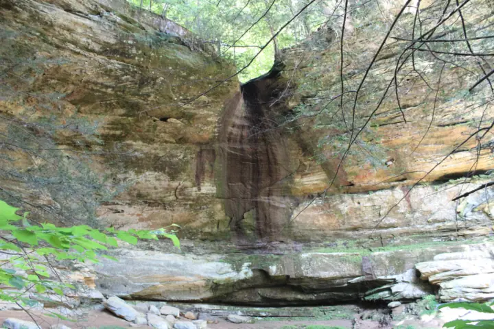
Yes, but it is seasonal. The ODNR park map draws a waterfall icon on Buck Run, just west of The Squeeze, near the bottom of the Gorge Trail. ODNR's park page does not describe it, and we found no published height.
It may be a trickle in summer. A Wikimedia Commons photo by Aaron Zhu, taken in August 2013, shows it nearly dry. A 2022 Columbus Dispatch report referred to the 'main waterfall' here.
Geology
ODNR says the park's rock is Black Hand Sandstone, deposited over 350 million years ago. Its softer middle zone wore away into recess caves, ODNR adds, and the page also notes honeycomb weathering and slump blocks.
CCC history
ODNR's park page says Civilian Conservation Corps Camp Logan, Company 526, was a camp of Black workers at Cantwell Cliffs. It was set up in 1933, ODNR says, and its crews worked on Cantwell Cliffs, Rock House and Rock Bridge.
About our map pin
Our map pin is the USGS GNIS point for Cantwell Cliffs (feature ID 1038805), classed as a cliff. Directions go to the parking lot, using the OpenStreetMap lot center. By our math, the lot is about 0.3 mile south of the pin in a straight line.
Getting there and parking
The ODNR park map inset puts the parking lot at the south end of the Cantwell Cliffs trails. Restrooms, the trailhead, picnic areas and a shelter house sit beside it. The map labels no road at the lot, so use our directions link.
Plan a separate drive to Cantwell Cliffs. By our math, our pin is about 7.8 miles from Old Man's Cave, 9.0 miles from Cedar Falls and 10.4 miles from Ash Cave in straight lines.
ODNR's park page lists a reservable shelter house at Cantwell Cliffs. It also says each trailhead lot has a picnic area with tables, grills and latrines.
Fees
Ohio's Governor's office said on Sep 17, 2025 that all 76 state parks have free entry. We saw no entry or parking fee on ODNR's Hocking Hills park page or its park map, read Nov 13, 2026. Confirm any charges with the park office.
Hours and contact
ODNR says trails and picnic areas are open from half an hour before sunrise to half an hour after sunset. The park map asks visitors to exit trails before the park closes at dark.
The park office is at (740) 385-6842, 8am to 4:30pm on weekdays, per ODNR. The Visitor Center is not here; ODNR places it at the Old Man's Cave lot off State Route 664.
Map and nearby falls
Map loads as you scroll. Open in OpenStreetMap
OpenPartly open / seasonalUnconfirmedClosedLarger map
The walk
ODNR gives two figures for Cantwell Cliffs. Its park page lists 2 miles, rated difficult. Its park map shows the Cantwell Rim Trail at 1.1 miles with a red blaze and the Gorge Trail at 0.2 mile with a yellow blaze.
By our math, the two mapped trails add up to 1.3 miles. The park page figure may include connecting paths. We found no official walking time or elevation gain.
One way, with many steps
The map marks one-way arrows on the loop, and ODNR's park page says many trails have been rerouted for one-way hiking. Follow the directional signs.
Steps are marked on the descent from the rim and on the climbs out of the gorge, per the ODNR map. Take your time on them, especially when they are wet.
The Squeeze
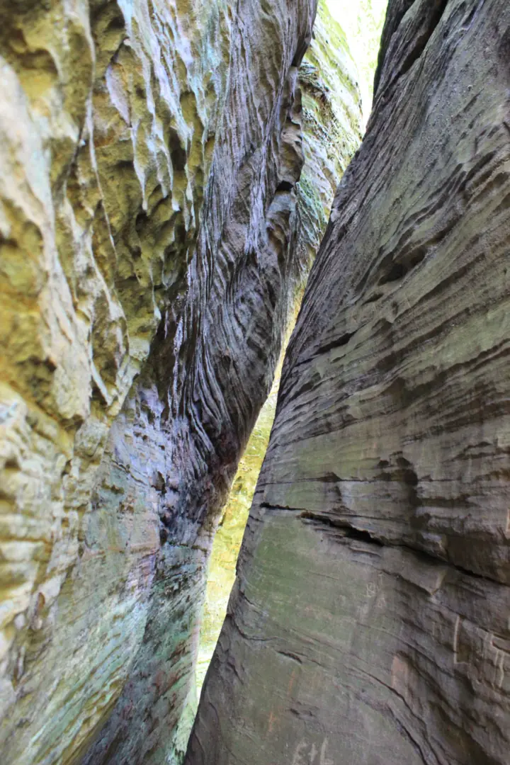
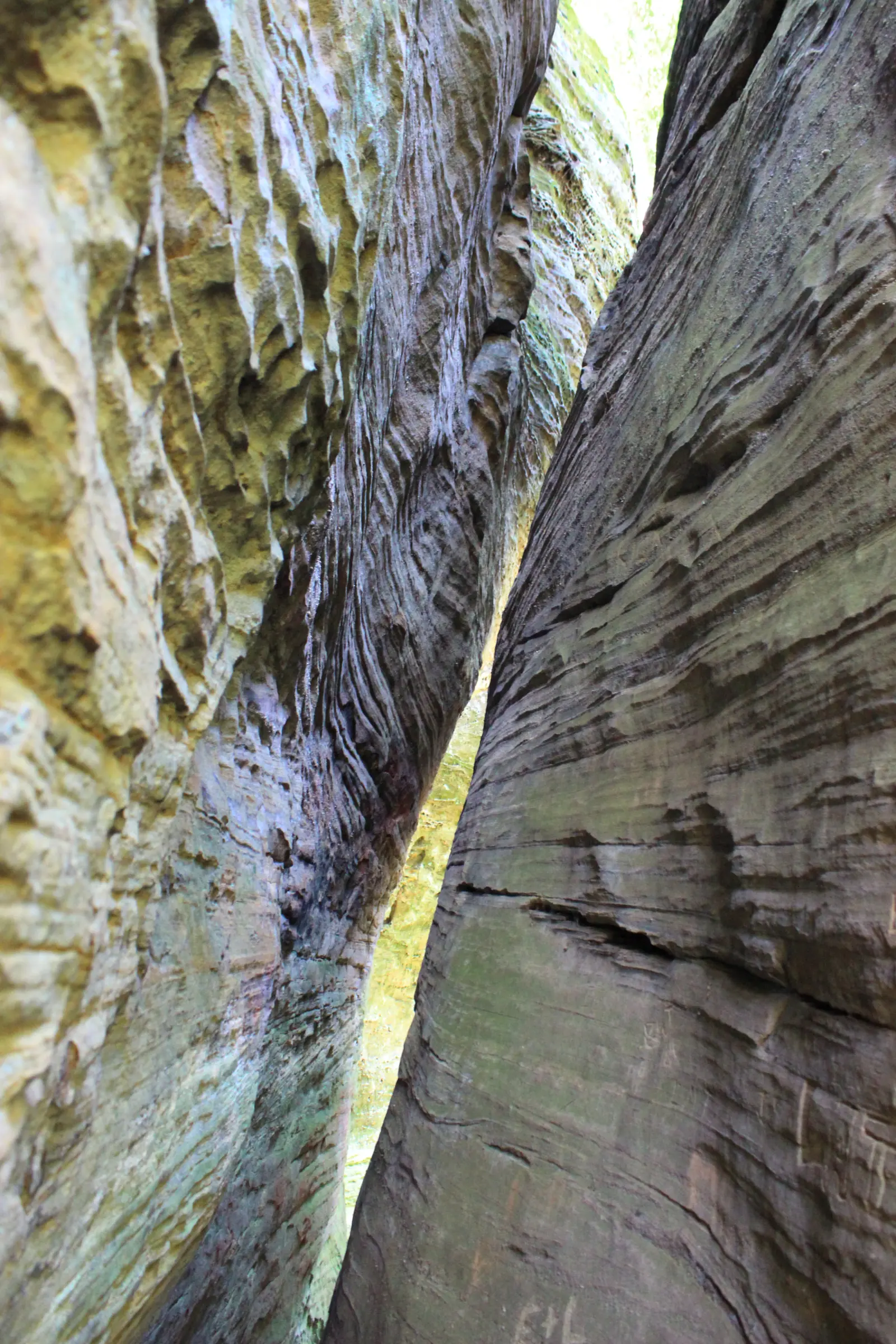
The Squeeze is a narrow passage between sandstone walls, labelled on the ODNR park map with a unique geology icon. The map places it near the Buck Run waterfall icon.
Dogs
Dogs are welcome on a leash. The ODNR park map says dogs must be on a 6 ft leash. Expect steps and tight spots on this loop.
When to visit
ODNR gives no best season for Cantwell Cliffs. The waterfall is seasonal, and it may be a trickle in summer. A Commons photo from August 2013 shows it nearly dry.
Winter
ODNR warns that park trails are typically covered in ice in winter and recommends ice cleats. Its park page also lists ice formations as a winter draw. The steps here make cleats worth packing.
Status checks
On Nov 13, 2026, ODNR's park page showed no closure for Cantwell Cliffs, so we list it as open. We could not read a current ODNR alerts block. Call the park office before you drive up.
Nearby, Conkle's Hollow is a separate state nature preserve with its own gorge. By our math it is about 5.7 miles from our Cantwell pin. Compare more falls in our Ohio waterfalls guide.
| Trail | ODNR's park page lists Cantwell Cliffs at 2 miles, difficult. ODNR's park map (Rev 08/2024) shows the Cantwell Rim Trail at 1.1 miles (red) and the Gorge Trail at 0.2 mile (yellow), one way, with many steps |
|---|---|
| Difficulty | Difficult, per the ODNR park page; many steps and a one-way loop on the ODNR park map |
| Entry fee | Ohio state parks charge no entrance fee, per a Sep 17, 2025 Ohio Governor's office bulletin. ODNR's Hocking Hills park page and park map list no entry or parking fee (read Nov 13, 2026) |
| Permit / reservation | No permit or ticket listed by ODNR for the trails |
| Parking | Lot at the south end; no fee listed |
| Hours / season | Trails 1/2 hour before sunrise to 1/2 hour after sunset (ODNR park page) |
| Dogs | Allowed on a leash. The ODNR park map says 'Dogs must be on a 6ft leash.' |
| Swimming | No. The ODNR park map says 'No swimming or wading in any water.' It also says to stay on the trail |
| Wheelchair / stroller | No official accessible designation. The ODNR park map marks many steps here, and ODNR's park page lists only the Ash Cave Gorge trail as wheelchair accessible |
| Restrooms | Restrooms near the south-end parking lot, per the ODNR park map inset |
| Crowds | No official visitor figure found. |
| Managed by | Ohio Department of Natural Resources, Division of Parks and Watercraft |
Safety and swimming
The cliffs here are high, and people have died in falls. On July 27, 2022, a hiker was found dead at the base of a cliff, the Columbus Dispatch reported. The person was believed to have left the trail near the main waterfall.
ODNR then reminded visitors to 'stay on the trails and follow park safety regulations,' per the Dispatch. On May 20, 2026, a visitor died after a fall at Cantwell Cliffs, ABC6 reported. ODNR again urged people to stay on marked trails.
Keep to the marked path at all times, as ODNR's park page requires. The park map adds that all identified waterfalls can be seen from the trails, so there is no need to leave them.
Stay out of the water. The ODNR park map says 'No swimming or wading in any water.' It also warns hikers to use caution on muddy, wet or icy trails.
Do not climb the rock walls. ODNR places the area's rock climbing and rappelling site in the adjacent Hocking State Forest. Supervise children closely, as ODNR asks. Read our waterfall safety guide before you go.
Where to stay near Cantwell Cliffs
Compare hotels, cabins and rentals close to the falls around Logan.
See places to stay nearbyAffiliate link: we may earn a commission at no cost to you. Partners do not see or change our waterfall facts. Disclosure.
Photos
Cantwell Cliffs FAQ
Is there a waterfall at Cantwell Cliffs?
Yes, a seasonal one. The ODNR park map draws a waterfall icon on Buck Run near The Squeeze. It may be a trickle in summer. A Commons photo from August 2013 shows it nearly dry. No height is published.
How long is the Cantwell Cliffs trail?
ODNR's park page lists 2 miles, rated difficult. ODNR's park map shows the Cantwell Rim Trail at 1.1 miles and the Gorge Trail at 0.2 mile. By our math, those two add up to 1.3 miles.
What is The Squeeze at Cantwell Cliffs?
It is a narrow passage between sandstone walls, labelled on the ODNR park map with a unique geology icon. The map places it near the Buck Run waterfall icon on the gorge loop.
Is Cantwell Cliffs hard to hike?
ODNR rates it difficult. Its park map shows a one-way loop with many sets of steps on the rim descent and the gorge climbs. Trails can be muddy, wet or icy, the map warns.
Can I bring my dog to Cantwell Cliffs?
Yes. The ODNR park map says dogs must be on a 6 ft leash. Expect steps and tight spots along the loop.
Can you swim at Cantwell Cliffs?
No. The ODNR park map says no swimming or wading in any water, and visitors must stay on the trail.
Is there a fee to visit Cantwell Cliffs?
Ohio's Governor's office said on Sep 17, 2025 that all 76 state parks have free entry. We saw no entry or parking fee on ODNR's park page or map, read Nov 13, 2026. Call (740) 385-6842 to confirm.
Have people been hurt at Cantwell Cliffs?
Yes. News reports describe fatal falls on July 27, 2022 (Columbus Dispatch) and May 20, 2026 (ABC6). In 2022, the hiker was believed to have left the trail. ODNR urges visitors to stay on marked trails.
Nearby waterfalls

Sources
Some facts credited to the Ohio DNR come from search-result excerpts of its official pages. Confirm fees and rules on the official site.
- ODNR: Hocking Hills State Park (trails, hours, shelter houses, CCC history, geology; read Nov 13, 2026; no page date shown)
- ODNR: Hocking Hills park map PDF (Cantwell Cliffs inset, trail lengths, rules; Rev 08/2024; read Nov 13, 2026)
- Columbus Dispatch via Yahoo: hiker found dead at bottom of cliff at Cantwell Cliffs (Jul 28, 2022; read Nov 13, 2026)
- ABC6 (WSYX) news report: fatal fall at Cantwell Cliffs, Hocking Hills State Park (May 21, 2026; read Nov 13, 2026)
- Wikimedia Commons: Fall near Cantwell Cliffs, photo by Aaron Zhu, Aug 14, 2013 (read Nov 13, 2026)
- USGS GNIS: Cantwell Cliffs (Cliff), feature ID 1038805 (read Nov 13, 2026)
- OpenStreetMap: Cantwell Cliffs parking, way 468022318 (read Nov 13, 2026)
- Ohio Governor's office: free entry to all 76 state parks (Sep 17, 2025; read Nov 13, 2026)

Last verified Nov 13, 2026 by The Waterfall Guide editorial team. Conditions change: confirm with Ohio Department of Natural Resources, Division of Parks and Watercraft before you go. Spotted something out of date? Report a correction.